
-
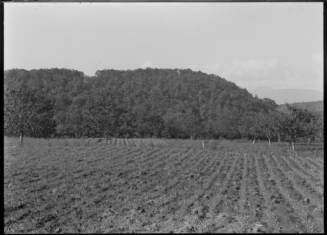
No. JCY_01 Description Jichin’yama Stone Circle, distant view(from the east) Photographed year 1949 Size Cabinet photographic plate Plate No. of the report Box No. H45_010 Comment This photograph was taken at the Jichin’yama Site from the east, which is located 50 m above. Alternatively, PL. ⅩⅩⅧ-1 printed in Otoe (Komai 1959) was taken from the west. -
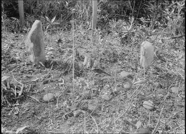
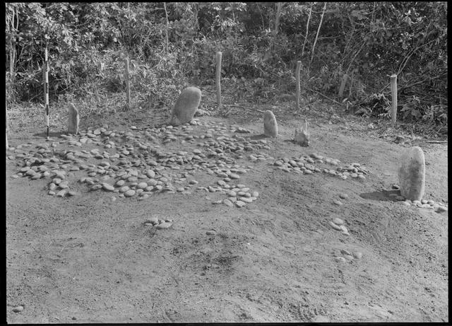
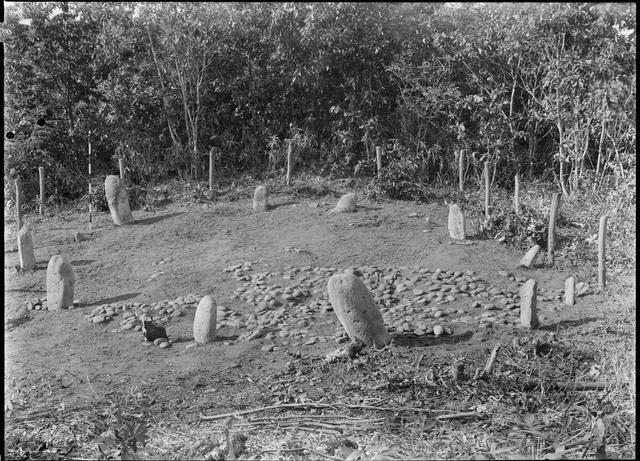
No. JCY_02 Description Jichin’yama Stone Circle, standing stones in the southeast part of the stone circle (from the northwest) Photographed year 1949 Size Cabinet photographic plate Plate No. of the report Box No. H45_006 Comment This stone circle has an oval shape in which the long axis tilts northwest and measures approximately 10 m in the major axis and 8 m in the minor axis. This photograph, taken before the excavation, shows two standing stones located in the southwest part of the stone circle. -
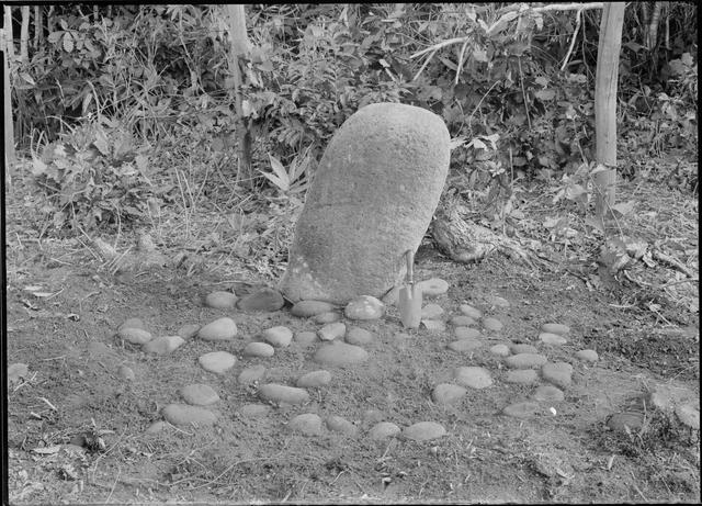
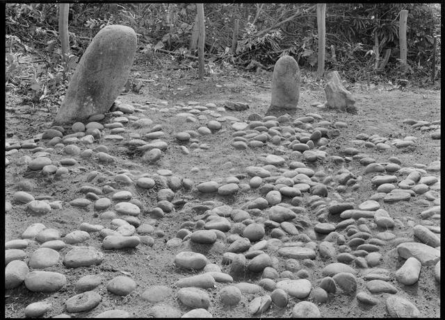
No. JCY_03 Description Jichin’yama Stone Circle, standing stone, and stacked stones in the south part of the stone circle (from the northwest) Photographed year 1949 Size Cabinet photographic plate Plate No. of the report Box No. H46_013 Comment This photograph shows the standing stone located on the south side of the standing stones in JCY_02. There are several stacked stones made from rounded stones found on the ground in front (inside the circle) of the standing stone. -
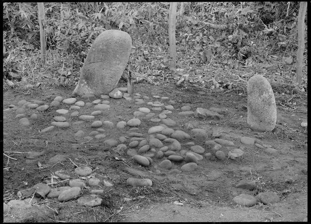
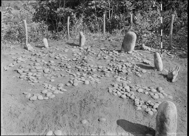
No. JCY_04 Description Jichin’yama Stone Circle, standing stones, and stacked stones in the south part of the stone circle (from the northwest) Photographed year 1949 Size Cabinet photographic plate Plate No. of the report Box No. H46_007 Comment This photograph also shows the standing stones in JCY_02 and another standing stone located to the west of the stone above. There are some round stacked stones on the ground in front (inside the circle) of the standing stones. -
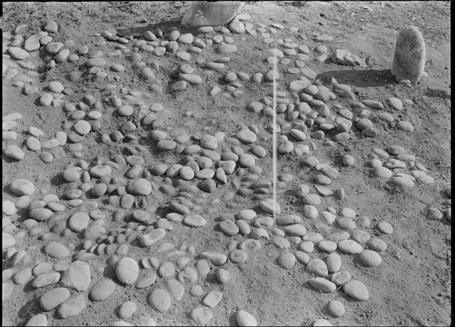
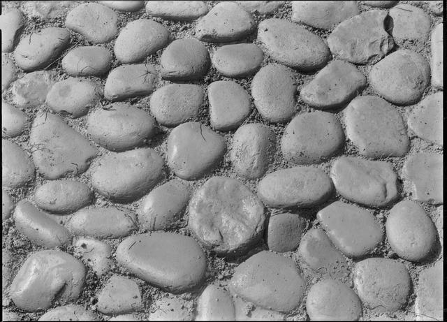
No. JCY_05 Description Jichin’yama Stone Circle, stacked stones inside the standing stones (from the northwest) Photographed year 1949 Size Cabinet photographic plate Plate No. of the report Box No. H46_015 Comment This photograph clearly shows the stacked stones excavated in the ground inside the standing stones. Stacked stones were only found in the southeast part of the inside of the standing stones and were distributed across the area measuring approximately 5.8 m in the major axis and 3.5 m in the minor axis. -
No. JCY_06 Description Jichin’yama Stone Circle, the stacked stones inside the standing stones (from the west) Photographed year 1949 Size Cabinet photographic plate Plate No. of the report Komai 1959: PL. ⅩⅩⅩ-1 Box No. 43_04 Comment This photograph was taken of the stacked stones in JCY_05 from the west. -
No. JCY_07 Description Jichin’yama Stone Circle, the stacked stones inside the standing stones, short-distance view (from the northwest) Photographed year 1949 Size Cabinet photographic plate Plate No. of the report Box No. H46_008 Comment This photograph shows a short-distance view of the south part of the stacked stones in JCY_05. -
No. JCY_08 Description Jichin’yama Stone Circle, stacked stones inside the standing stones, short-distance view (from the north) Photographed year 1949 Size Cabinet photographic plate Plate No. of the report Box No. H46_014 Comment This photograph shows a short-distance view of the south part of the stacked stones in JCY_05. This photograph was taken with a low camera angle from the northeast. -
No. JCY_09 Description Jichin’yama Stone Circle, panoramic view (from the southeast) Photographed year 1949 Size Cabinet photographic plate Plate No. of the report Komai 1959: PL. ⅩⅩⅨ-1 Box No. 43_07 Comment This photograph shows a panoramic view of the stone circle. The stacked stones were found after excavating the ground surface inside the standing stones and were only located in the southeast part of the interior of the standing stones. -
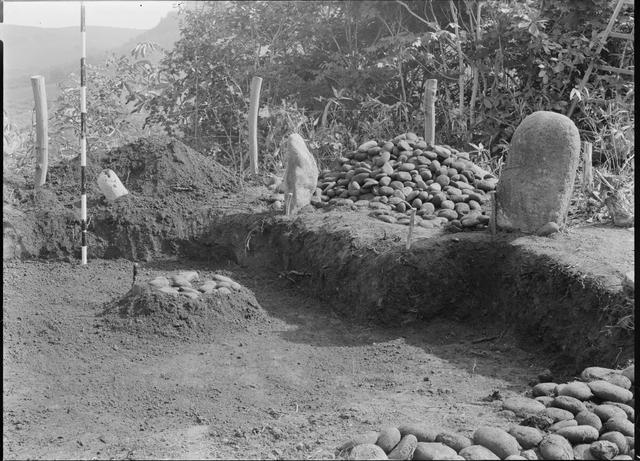
No. JCY_10 Description Jichin’yama Stone Circle, excavation after removing the stacked stones (from the west) Photographed year 1949 Size Cabinet photographic plate Plate No. of the report Box No. H46_009 Comment This photograph shows the state of excavation after removing the stacked stones. Almost all the stacked stones were already excavated at this point. It can be seen that the excavation area was wider than the area of the square-shaped burial pit in JCY_18 and JCY_19. -
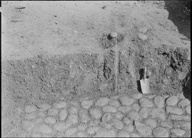
No. JCY_11 Description Jichin’yama Stone Circle, flagstones on the floor of the burial pit (from the southwest) Photographed year 1949 Size Cabinet photographic plate Plate No. of the report Box No. H46_012 Comment The burial pit measured approximately 2 m square and 1 m deep after the stacked stones were excavated. The round stones lay over the floor of the burial pit. This photograph shows the flagstones slightly inside the pit and the sections of the fill strata. It is surely that the northwest wall of this burial pit was located approximately 0.3 m toward the northeast side of this section. -
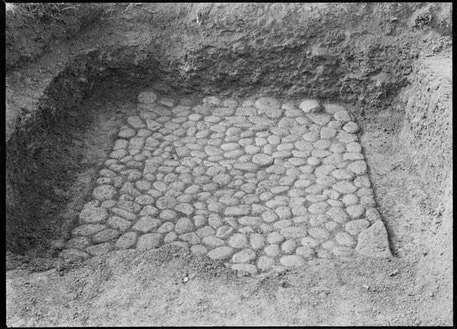
No. JCY_12 Description Jichin’yama Stone Circle, flagstones on the floor of the burial pit (from the northeast) Photographed year 1949 Size Cabinet photographic plate Plate No. of the report Box No. H46_010 Comment This photograph shows the burial pit after excavating the flagstones on the floor under the stacked stones. The stones were placed over the horizontally square-shaped area measuring 2.12 m horizontally (from northeast to southwest) and 1.75 m vertically (from northwest to southeast). PL. ⅩⅩⅩⅠ-2 in Otoe is the corresponding photograph taken from the right side. -
No. JCY_13 Description Jichin’yama Stone Circle, short-distance view of the stacked stones on the floor of the burial pit (from the northeast) Photographed year 1949 Size Cabinet photographic plate Plate No. of the report Box No. H46_005 Comment This photograph shows a short-distance view of the stacked stones in JCY_12 which are slightly off-center. -
No. JCY_14 Description Jichin’yama Stone Circle, short-distance view of the stacked stones on the floor of the burial pit (from the south) Photographed year 1949 Size Cabinet photographic plate Plate No. of the report Box No. H46_006 Comment This photograph shows the northern corner of the stacked stones in JCY_12. -
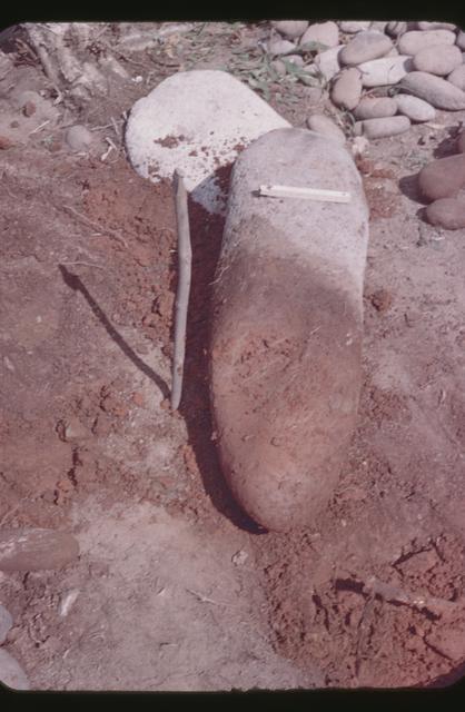
No. JCY_15 Description Jichin’yama Stone Circle, excavated standing stone Photographed year 1949 Size 35mm Plate No. of the report Box No. S6_11 Comment This stone is the same as the standing stone in PL. ⅩⅩⅩ-2, Komai (1959), which was located on the southeast end of the stone circle (photographed in JCY_03 and others). -
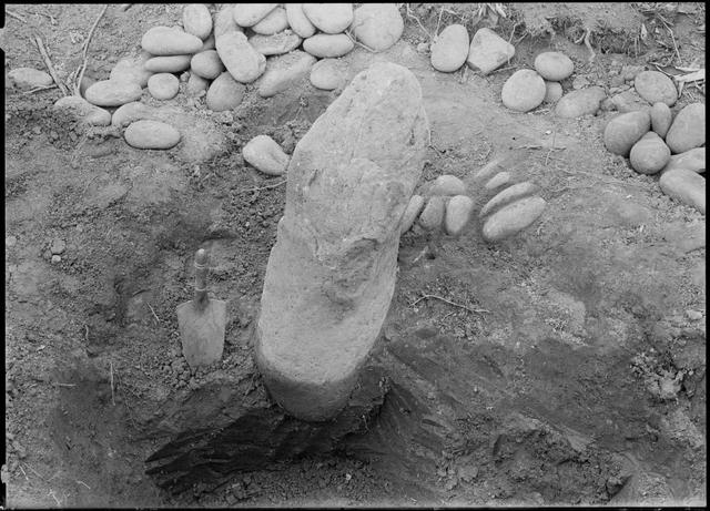
No. JCY_16 Description Jichin’yama Stone Circle, excavating standing stone (from the south?) Photographed year 1949 Size Cabinet photographic plate Plate No. of the report Box No. H46_001 Comment This photograph shows the excavation of the base of the standing stone. The standing stone was located on the eastern end of the stone circle (the stone on the left side in JCY_02). -
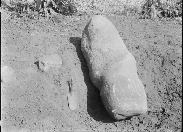
No. JCY_17 Description Jichin’yama Stone Circle, excavated standing stone Photographed year 1949 Size Cabinet photographic plate Plate No. of the report Box No. H46_002 Comment This photograph shows the state after excavating the standing stone in JCY_16. -
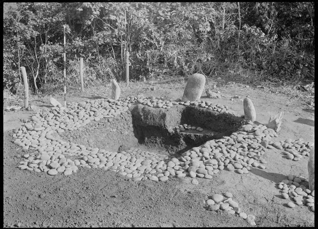
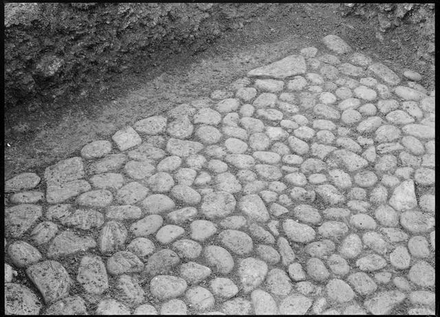
No. JCY_18 Description Jichin’yama Stone Circle, reconstruction after excavating (from the west) Photographed year 1949 Size Cabinet photographic plate Plate No. of the report Komai 1973: Fig. 2 Box No. H46_003 Comment This photograph shows the reconstruction of the stacked stones and part of the standing stones after backfilling the excavation area (northeastern part of the area) which is located on outside of the burial pit after excavating under the stacked stones. It is noteworthy that the density of the stacked stones after the reconstruction is higher than that before the excavation. -
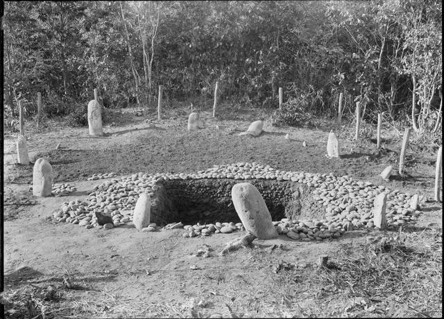
No. JCY_19 Description Jichin’yama Stone Circle, reconstruction after excavating (from the southeast) Photographed year 1949 Size Cabinet photographic plate Plate No. of the report Komai 1959: PL. ⅩⅩⅨ-2 Box No. 43_05 Comment This is an aerial view of the stone circle reconstructed after the excavation.
- Prev.
- |
- Next


Copyright © Tokoro Research Laboratory of the University of Tokyo, Graduate School of Humanities and Sociology. All rights reserved.